
This is the universal build of German Topo Maps 7.8.0. It contains native libraries for every CPU architecture (arm64-v8a, armeabi-v7a, x86, x86_64), so it installs on any Android device. The trade-off is size — it's larger than per-architecture variants. Pick this one if you're unsure which CPU your phone has, or if you plan to share the APK with multiple devices.
File size: 21.4 MB • Min Android: 24 • Target Android: 35 • Version code: 397 • Framework: Native (Java/Kotlin) • Permissions: 21
Screenshots
File Information
| Package Name | com.atlogis.germany |
|---|---|
| Version Name | 7.8.0 |
| Version Code | 397 |
| Architecture | Universal |
| Min Android Version | Android 24 (API 35) |
| Main Activity | com.atlogis.mapapp.MapAppStartActivity2 |
| Framework | Native (Java/Kotlin) |
| File Size | 21.36 MB |
| Signature (SHA1) | D8C68E174BAEBEECB8F78CE96D0766554DD0F85C |
| File Hash (SHA256) | 3bc65e53c90c07bad005793f06de4bb44b66dfb108e681619b4f8492b1796d8b |
What's New
・Shapes: Anzeige von Vektor-Features aus shape, geojson oder kml Dateien
・Unterstützung für Android 15
・Verbesserungen & Korrekturen
・Unterstützung für Android 15
・Verbesserungen & Korrekturen
App Description
+++ NEW ! Introductory Price ! Get the full features for a small one time fee. !!! +++
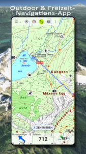
Easy to use Outdoor/Offline GPS navigation app with access to the best topographic maps and satellite images for Norway.
++ For offline use PRO features needed ! ++
Turn your Andoid Phone/Tablet into an outdoor GPS for trips into the backcountry WITHOUT CELL COVERAGE. See your position on different maps, record your track or share your location with others.
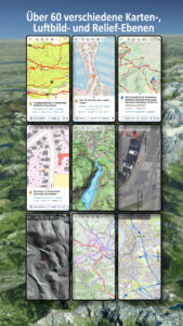
Over 50 different map layers for Germany. 10 map layers with worldwide coverage. Plus many overlays like trekking or bicycle routes.
Use official topographical maps to find small pathes, creeks or contour lines.
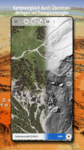
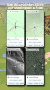
High resolution aerial imagery, topo maps in up to 1:5.000, digital terrain modells and even cadastre maps for many German states !
OpenStreetMaps with different layouts.
Free map layers for all Germany
• TopPlus: These high resolution maps use best available geodata from German surveying office (BKG)
• WebAtlasDE
• Satellite imagery
• OpenStreetMaps : These crowdsourced maps are a very useful addition to other map layers. Contain many unique features.
• OpenCycleMaps: These maps are ideal to plan bicycle trips (PRO Users only !)
• ESRI Topographic
• ESRI Aerial Images
• ESRI Street Map
• Google Road Map (online access only)
• Google Satellite Images (online access only)
• Google Terrain Map (online access only)
• Bing Road Map (online access only)
• Bing Satellite Images (online access only)
• Earth At Night
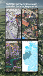
• lots of Overlays like hillshading, rivers, lakes, routes, ...
Main features for outdoor-navigation:
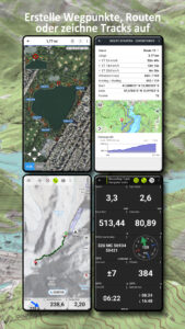
• Create and edit Waypoints
• GoTo-Waypoint-Navigation
• Track Recording (with speed, elevation and accuracy profile)
• Tripmaster with fields for odometer, average speed, bearing, elevation, etc.
• GPX/KML/KMZ Export
• Search (placenames, POIs, streets)
• Customizable datafields in Map View and Tripmaster (e.g. Speed, Distance, Compass, ...)
• Share Waypoints, Tracks or Routes (via eMail, Whatsapp, Dropbox, Facebook, ..)
• Display coordinates in Lat/Lon, UTM or MGRS/USNG (Military Grid/ US National Grid)
• Record & share tracks with statistics & elevation profile
• Rotate map (Track Up & North Up)
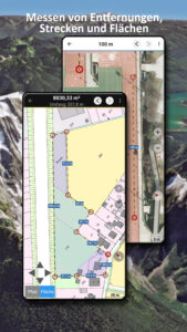
• Get Elevation and Distance by long click on map
• Track Replay
• Add custom map tile servers
• and many more ...
Available Pro features: (Pro features available via In App Purchase)
• Offline Use - no cell coverage needed. No Roaming fees !
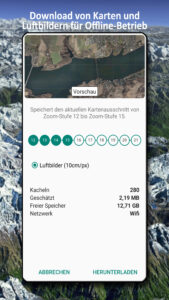
• Easy+Fast Bulk-download of map tiles for OFFLINE USAGE (not for Google and Bing maps)
• Create and edit Routes
• Route-Navigation (Point-to-Point Navigation)
• GPX/KML/KMZ Import/Export
• unlimited Waypoints & Tracks
• Add other Map Tile-Server
• No Ads
Offline Use:
All viewed map tiles are kept in cache. To cache large areas you need to purchase Pro features.
Use this navigation app for outdoor activities like hiking, biking, camping, climbing, riding, skiing, canoeing, hunting, offroad 4WD tours or search&rescue (SAR).
Add custom waypoints in longitude/latitude, UTM or MGRS/USNG format with WGS84 datum.
Import/Export/Share GPS-Waypoints/Tracks/Routes in GPX or Google Earth KML/KMZ format.
Preload FREE map data for areas without cell service (Pro feature !).
Comments and feature requests to
info@atlogis.com
Have a look at our other outdoor navigation apps:
play.google.com/store/search?q=atlogis
+++ We DO NOT track any user activities or collect any user data ! +++
Easy to use Outdoor/Offline GPS navigation app with access to the best topographic maps and satellite images for Norway.
++ For offline use PRO features needed ! ++
Turn your Andoid Phone/Tablet into an outdoor GPS for trips into the backcountry WITHOUT CELL COVERAGE. See your position on different maps, record your track or share your location with others.
Over 50 different map layers for Germany. 10 map layers with worldwide coverage. Plus many overlays like trekking or bicycle routes.
Use official topographical maps to find small pathes, creeks or contour lines.
High resolution aerial imagery, topo maps in up to 1:5.000, digital terrain modells and even cadastre maps for many German states !
OpenStreetMaps with different layouts.
Free map layers for all Germany
• TopPlus: These high resolution maps use best available geodata from German surveying office (BKG)
• WebAtlasDE
• Satellite imagery
• OpenStreetMaps : These crowdsourced maps are a very useful addition to other map layers. Contain many unique features.
• OpenCycleMaps: These maps are ideal to plan bicycle trips (PRO Users only !)
• ESRI Topographic
• ESRI Aerial Images
• ESRI Street Map
• Google Road Map (online access only)
• Google Satellite Images (online access only)
• Google Terrain Map (online access only)
• Bing Road Map (online access only)
• Bing Satellite Images (online access only)
• Earth At Night
• lots of Overlays like hillshading, rivers, lakes, routes, ...
Main features for outdoor-navigation:
• Create and edit Waypoints
• GoTo-Waypoint-Navigation
• Track Recording (with speed, elevation and accuracy profile)
• Tripmaster with fields for odometer, average speed, bearing, elevation, etc.
• GPX/KML/KMZ Export
• Search (placenames, POIs, streets)
• Customizable datafields in Map View and Tripmaster (e.g. Speed, Distance, Compass, ...)
• Share Waypoints, Tracks or Routes (via eMail, Whatsapp, Dropbox, Facebook, ..)
• Display coordinates in Lat/Lon, UTM or MGRS/USNG (Military Grid/ US National Grid)
• Record & share tracks with statistics & elevation profile
• Rotate map (Track Up & North Up)
• Get Elevation and Distance by long click on map
• Track Replay
• Add custom map tile servers
• and many more ...
Available Pro features: (Pro features available via In App Purchase)
• Offline Use - no cell coverage needed. No Roaming fees !
• Easy+Fast Bulk-download of map tiles for OFFLINE USAGE (not for Google and Bing maps)
• Create and edit Routes
• Route-Navigation (Point-to-Point Navigation)
• GPX/KML/KMZ Import/Export
• unlimited Waypoints & Tracks
• Add other Map Tile-Server
• No Ads
Offline Use:
All viewed map tiles are kept in cache. To cache large areas you need to purchase Pro features.
Use this navigation app for outdoor activities like hiking, biking, camping, climbing, riding, skiing, canoeing, hunting, offroad 4WD tours or search&rescue (SAR).
Add custom waypoints in longitude/latitude, UTM or MGRS/USNG format with WGS84 datum.
Import/Export/Share GPS-Waypoints/Tracks/Routes in GPX or Google Earth KML/KMZ format.
Preload FREE map data for areas without cell service (Pro feature !).
Comments and feature requests to
info@atlogis.com
Have a look at our other outdoor navigation apps:
play.google.com/store/search?q=atlogis
+++ We DO NOT track any user activities or collect any user data ! +++
Download German Topo Maps APK
Fast, free and safe download.
APK Permissions 21
- android.permission.ACCESS_ADSERVICES_AD_ID
- android.permission.ACCESS_ADSERVICES_ATTRIBUTION
- android.permission.ACCESS_ADSERVICES_TOPICS
- android.permission.ACCESS_BACKGROUND_LOCATION
- android.permission.ACCESS_COARSE_LOCATION
- android.permission.ACCESS_FINE_LOCATION
- android.permission.ACCESS_NETWORK_STATE
- android.permission.FOREGROUND_SERVICE
- android.permission.FOREGROUND_SERVICE_DATA_SYNC
- android.permission.FOREGROUND_SERVICE_LOCATION
- android.permission.INTERNET
- android.permission.POST_NOTIFICATIONS
- android.permission.READ_EXTERNAL_STORAGE
- android.permission.REQUEST_IGNORE_BATTERY_OPTIMIZATIONS
- android.permission.VIBRATE
- android.permission.WAKE_LOCK
- android.permission.WRITE_EXTERNAL_STORAGE
- com.android.vending.BILLING
- com.atlogis.germany.DYNAMIC_RECEIVER_NOT_EXPORTED_PERMISSION
- com.google.android.finsky.permission.BIND_GET_INSTALL_REFERRER_SERVICE
- com.google.android.gms.permission.AD_ID
APK Verified
The cryptographic signature guarantees that the file is safe to install and was not tampered with in any way.
Similar in Maps & Navigation


More by ATLOGIS Geoinformatics GmbH & Co. KG


Frequently Asked Questions about German Topo Maps APK
This is the universal variant — a single APK that contains native libraries for every CPU architecture. It installs on any Android device but is larger than per-architecture variants.
Yes — the APK's signature has been cryptographically verified against the publisher's signing key. The SHA-256 hash is shown in the File Information panel so you can independently confirm the file matches the original release.
Android 24 (API level 35) or newer. Older devices will refuse the install.
Install a free app like 'CPU-Z' or 'Droid Hardware Info' from the Play Store and look at the ABI / Instruction Set row. Most phones made after 2017 are arm64-v8a; if in doubt, download the universal variant.
All variants are functionally identical — same features, same version. They differ only in which CPU architectures the native code is compiled for, and (sometimes) which screen densities the included graphics target. Pick the one that matches your device for the smallest install size, or pick 'Universal' if you're unsure.