Screenshots
File Information
| Package Name | com.atlogis.germany |
|---|---|
| Version Name | 7.8.5 |
| Version Code | 423 |
| Architecture | Universal |
| Min Android Version | Android 24 (API 35) |
| Main Activity | com.atlogis.mapapp.MapAppStartActivity2 |
| Framework | Native (Java/Kotlin) |
| File Size | 21.64 MB |
| Signature (SHA1) | D8C68E174BAEBEECB8F78CE96D0766554DD0F85C |
| File Hash (SHA256) | f89cc4090a51a5ea12d5f47662cf43727ad76fe719f6e0c97704567915fc3e08 |
What's New
・Verbesserungen & Korrekturen
App Description
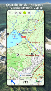
Easy-to-use leisure navigation app with the best topographic maps and aerial photographs for Germany.
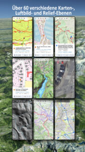
Over 60 different map types for Germany. Plus 13 map layers with worldwide coverage and numerous overlays, such as hiking and cycling trails.
In addition to worldwide OpenStreetMap (OSM) maps in various styles, you have access to detailed official maps from the Federal Office of Cartography (BKG) and the respective state surveying offices.
Resolution aerial photographs, official topographic maps (DTK series 1:10,000 - 1:100,000), and property maps (ALKIS) are available for all federal states (except Baden-Württemberg).
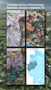
There are also numerous optional overlays, such as hiking and cycling trails, bodies of water, contour lines, and hillshading.
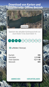
Maps and aerial photographs can be downloaded free of charge for specific regions, so you don't need an internet connection while on the go.
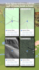
Digital terrain models (DTMs) are available for many German states, allowing you to identify the finest structures in the ground (e.g., former border fences, foundation walls, or paths not shown on other maps).
There are also map layers from other commercial providers such as Google, ESRI, or Bing (these are only available online).
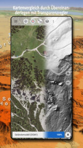
All maps can be applied as overlays and compared using a transparency slider.
There is no such thing as a perfect map - so with this app, you can decide which map is most suitable for your intended use and region.
The most important features for outdoor navigation:
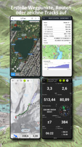
• Creating and editing waypoints
• GoTo waypoint navigation
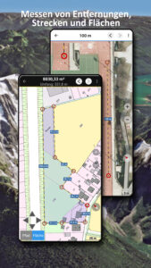
• Measuring distances and areas
• Tripmaster with data fields for daily mileage, average speed, bearing, elevation, etc.
• Search (place names, streets)
• Customizable data fields in map view (e.g., arrow, distance, compass, etc.)
• Sharing waypoints, tracks, or routes (via email, WhatsApp, Dropbox, Facebook, etc.)
• Using coordinates in WGS84, UTM, or MGRS
• Recording and sharing tracks with statistics and elevation profiles
• Displaying elevation and distance by long-clicking on the map
• ...
Additional Pro features:
• Offline use without a data connection
• Easy downloading of map data for offline use (except Google & Bing)
• Creating and editing routes
• Route navigation (point-to-point navigation)
• GPX/KML/KMZ Import/Export
• Unlimited waypoints & tracks
• Add new tile servers, WMS map services, and MBTiles
• No advertising
Map layers for all of Germany:
• BKG Basemap.de: This map is based on ATKIS-Basis-DLM data, the best official map data available from BKG Germany.
• TopPlus: This layer also uses ATKIS-Basis-DLM data, but with a slightly different layout. Also available in Europe at a reduced resolution
• Germany Satellite Image 10m/pixel: Medium-resolution satellite images for Germany
• DGM5 Digital Terrain Model 5m/pixel
• Corine Land Use
World Map Layers:
• OpenStreetMaps: These collaboratively created maps are a great complement to official maps and are sometimes even more detailed
• OSM Outdoors: OpenStreetMap data with a focus on hiking trails, hillshading, and contour lines
• OpenCycleMaps: OpenStreetMap data with a focus on cycle and hiking trails
• ESRI Topographic, Aerial & Street
• Google Road, Satellite & Terrain Map (online connection only)
• Bing Road & Satellite Map (online connection only)
• Various overlays such as cycle and hiking trails, hillshading, or bodies of water
Maps of the German federal states:
• Aerial photographs (10-40cm per pixel)
• Digital topographic maps DTK10, DTK25 DTK50 and DTK100
• Digital Terrain Models (DTM)
• Property/Catalog Maps
• Various overlays such as waterways or hiking trails
Please send any questions to
support@atlogis.com
Over 60 different map types for Germany. Plus 13 map layers with worldwide coverage and numerous overlays, such as hiking and cycling trails.
In addition to worldwide OpenStreetMap (OSM) maps in various styles, you have access to detailed official maps from the Federal Office of Cartography (BKG) and the respective state surveying offices.
Resolution aerial photographs, official topographic maps (DTK series 1:10,000 - 1:100,000), and property maps (ALKIS) are available for all federal states (except Baden-Württemberg).
There are also numerous optional overlays, such as hiking and cycling trails, bodies of water, contour lines, and hillshading.
Maps and aerial photographs can be downloaded free of charge for specific regions, so you don't need an internet connection while on the go.
Digital terrain models (DTMs) are available for many German states, allowing you to identify the finest structures in the ground (e.g., former border fences, foundation walls, or paths not shown on other maps).
There are also map layers from other commercial providers such as Google, ESRI, or Bing (these are only available online).
All maps can be applied as overlays and compared using a transparency slider.
There is no such thing as a perfect map - so with this app, you can decide which map is most suitable for your intended use and region.
The most important features for outdoor navigation:
• Creating and editing waypoints
• GoTo waypoint navigation
• Measuring distances and areas
• Tripmaster with data fields for daily mileage, average speed, bearing, elevation, etc.
• Search (place names, streets)
• Customizable data fields in map view (e.g., arrow, distance, compass, etc.)
• Sharing waypoints, tracks, or routes (via email, WhatsApp, Dropbox, Facebook, etc.)
• Using coordinates in WGS84, UTM, or MGRS
• Recording and sharing tracks with statistics and elevation profiles
• Displaying elevation and distance by long-clicking on the map
• ...
Additional Pro features:
• Offline use without a data connection
• Easy downloading of map data for offline use (except Google & Bing)
• Creating and editing routes
• Route navigation (point-to-point navigation)
• GPX/KML/KMZ Import/Export
• Unlimited waypoints & tracks
• Add new tile servers, WMS map services, and MBTiles
• No advertising
Map layers for all of Germany:
• BKG Basemap.de: This map is based on ATKIS-Basis-DLM data, the best official map data available from BKG Germany.
• TopPlus: This layer also uses ATKIS-Basis-DLM data, but with a slightly different layout. Also available in Europe at a reduced resolution
• Germany Satellite Image 10m/pixel: Medium-resolution satellite images for Germany
• DGM5 Digital Terrain Model 5m/pixel
• Corine Land Use
World Map Layers:
• OpenStreetMaps: These collaboratively created maps are a great complement to official maps and are sometimes even more detailed
• OSM Outdoors: OpenStreetMap data with a focus on hiking trails, hillshading, and contour lines
• OpenCycleMaps: OpenStreetMap data with a focus on cycle and hiking trails
• ESRI Topographic, Aerial & Street
• Google Road, Satellite & Terrain Map (online connection only)
• Bing Road & Satellite Map (online connection only)
• Various overlays such as cycle and hiking trails, hillshading, or bodies of water
Maps of the German federal states:
• Aerial photographs (10-40cm per pixel)
• Digital topographic maps DTK10, DTK25 DTK50 and DTK100
• Digital Terrain Models (DTM)
• Property/Catalog Maps
• Various overlays such as waterways or hiking trails
Please send any questions to
support@atlogis.com
Download German Topo Maps APK
Fast, free and safe download.
APK Permissions 20
- android.permission.ACCESS_ADSERVICES_AD_ID
- android.permission.ACCESS_ADSERVICES_ATTRIBUTION
- android.permission.ACCESS_ADSERVICES_TOPICS
- android.permission.ACCESS_BACKGROUND_LOCATION
- android.permission.ACCESS_COARSE_LOCATION
- android.permission.ACCESS_FINE_LOCATION
- android.permission.ACCESS_NETWORK_STATE
- android.permission.FOREGROUND_SERVICE
- android.permission.FOREGROUND_SERVICE_LOCATION
- android.permission.INTERNET
- android.permission.POST_NOTIFICATIONS
- android.permission.READ_EXTERNAL_STORAGE
- android.permission.REQUEST_IGNORE_BATTERY_OPTIMIZATIONS
- android.permission.VIBRATE
- android.permission.WAKE_LOCK
- android.permission.WRITE_EXTERNAL_STORAGE
- com.android.vending.BILLING
- com.atlogis.germany.DYNAMIC_RECEIVER_NOT_EXPORTED_PERMISSION
- com.google.android.finsky.permission.BIND_GET_INSTALL_REFERRER_SERVICE
- com.google.android.gms.permission.AD_ID
APK Verified
The cryptographic signature guarantees that the file is safe to install and was not tampered with in any way.